The main Himalayan thrust and geometrical parameters
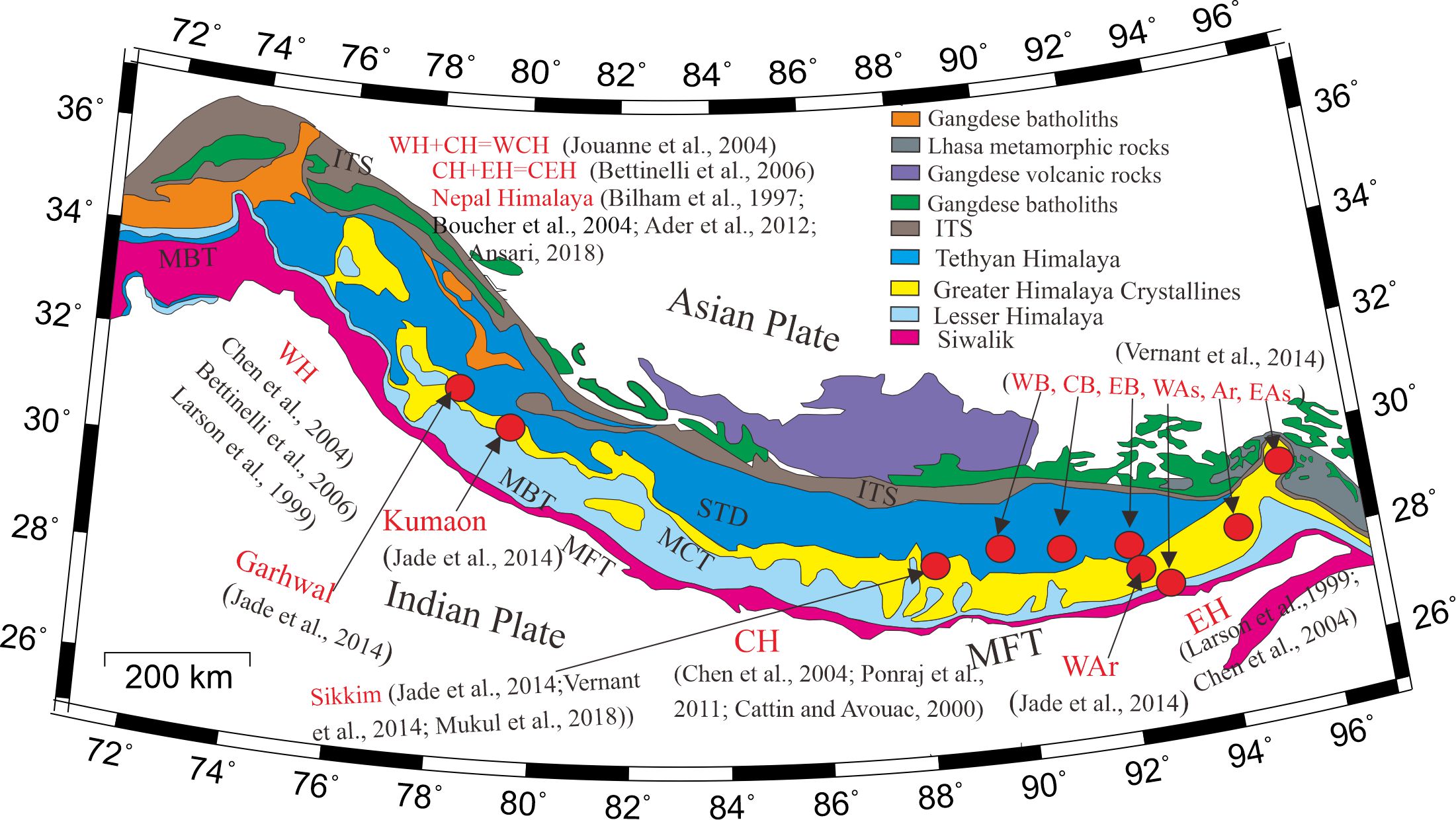
The near-surface expression of the Main Himalayan Thrust (MHT) is called the Main Frontal Thrust (MFT) (Gansser, 1983; Lavé and Avouac, 2001). There are another two major boundaries which are known as the Main Boundary Thrust (MBT) and the Main Central Thrust (MCT); they are also situated in the Himalayas. The MCT has been folded by the younger structure of Lesser Himalayan Duplex (Mitra et al, 2010) and the MBT has been folded by the South Kalijhora Thrust (SKT) in Darjiling-Sikkim-Tibet Himalaya (Mukul 2000). According to Boyer and Elliott (1982), if a fault gets folded by younger footwall faults in the fold-thrust belt, they then become inactive. Therefore, the MCT and the MBT are unlikely to be active seismogenic faults in the folded regions.
Several geophysical studies have been carried out in the Himalayas by using both active and passive sources of seismic experiments. These studies investigated the geometry of the MHT in different parts of the Himalayas such as Nepal Himalayas, central Nepal Himalayas, western Nepal Himalayas, and eastern Nepal Himalayas. The vertical displacement of the global positioning system network located in Nepal Himalayas was modelled by Ansari (2018). The observed displacements are modelled by the autoregressive moving average method. Their estimated single dislocation model showed a reverse slip rate of 19 m yr-1. The estimated length, depth, strike, and dip of finite rectangular were 700 km, 20 km, 277⁰, and 9.5⁰ respectively. These modelled parameters were similar to the parameters estimated by Jouanne et al. (2004) in the central Himalayas.
The geometry of the MHT in central and western Himalayas was modelled by Chen et al (2004). They determined that the Indian tectonic plate is locked ~80 km from Kathmandu in the north with ~102° strike, and a locked zone width of ~100 km. They also showed a slip rate of 12.2±0.4mmyr−1 with a shallower dip of ~3° between the longitudes of 83°E and 88°E. In central Himalaya, they found a slip rate of 17±1 mm yr−1 along the strike of 115°, a locking depth of around 18–20 km, and a steeper dip angle of around 9°. Larson (1999) modelled the Eastern Nepal Himalayan segment and reported a slip rate of 19.6 ± 1.1 mm yr−1 with a 3.4° dip to the north. The estimating result showed that the fault was located at a depth of 14.9 km. Later, Chen et al (2004) suggested a modelled slip rate of 19±1 mm yr−1 for India to go beneath Tibet in the eastern Himalaya with 84° strike. Although their modelled dip angle was shallower, the slip rate was lower, and the locked zone was slightly wider, their results were consistent with earlier estimations from the global positioning system measurements based on more limited data (Larson et al 1999).
Biography
Dr. Kutubuddin Ansari is Managing Director at Integrated Geoinformation (IntGeo) Solution Private Limited, New Delhi, India. He completed his Masters (Mathematics) from Kanpur University in 2008 and Ph.D. (GNSS Geodesy) from the Indian Institute of Technology Bombay, Mumbai, India in 2014. After getting his Ph.D., he worked as an Assistant Professor at Izmir Katip Celebi University, Izmir, Turkey. Later, he joined Kathmandu University, Nepal as an Assistant Professor for a period of 6 months. After that, Dr. Ansari moved to South Korea for postdoctoral work at Inha University, South Korea followed by Sejong University, Seoul, South Korea as a Full-time Researcher. His research interest involves multi-constellation GNSS systems and their application in geodesy and atmospheric modeling.
Detail
Dr. Kutubuddin Ansari
Managing Director, Integrated Geoinformation
Solution Private Limited, New Delhi, India (https://igeosol.com/)
Email: kdansari@igeosol.com
References
Ansari, K., 2018. Crustal deformation and strain analysis in Nepal from GPS time-series measurement and modeling by ARMA method. International Journal of Earth Sciences, 107(8), pp.2895-2905; doi.org/10.1007/s00531-018-1633-7Boyer, S. E. and Elliott, D. (1982). Thrust systems, American Association of Petroleum Geologists Bulletin, 66, 1196-1230
Chen, Q, Freymueller, JT, Wang, Q, Yang, Z, Xu, C, Liu, J, 2004. A deforming block model for the present‐day tectonics of Tibet. Journal of Geophysical Research: Solid Earth, 109(B1); doi.org/10.1029/2002JB002151
Gansser, A. (1983). Geology of the Bhutan Himalaya, Birkhauser Verlag Basel, 181.
Jouanne, F., Mugnier, J. L., Gamond, J. F., Le Fort, P., Pandey, M. R., Bollinger, L., et al. (2004). Current shortening across the Himalayas of Nepal. Geophysical Journal International, 157(1), 1–14. doi.org/10.1111/j.1365-246X.2004.02180.x
Larson, K., R. Burgmann, R. Bilham, and J. Freymuller (1999), Kinematics of the India-Eurasia collision zone from GPS measurements, J. Geophys. Res., 104, 1077–1093, doi.org/10.1029/1998JB900043
Lavé, J. and Avouac, J. P. (2001). Fluvial incision and tectonic uplift across the Himalayas of central Nepal, Journal of Geophysical Research, B: Solid Earth, 106 (B11), 26561-26591
Mitra, G., Bhattacharyya, K., and Mukul, M. (2010). The Lesser Himalayan Duplex in Sikkim: Implications for variations in Himalayan shortening, Journal of Geological Society of India, 75, 276-288.
Mukul, M. (2000). The Geometry and Kinematics of the Main Boundary Thrust and related Neotectonics in the Darjiling Himalayan Fold-and-thrust belt, West Bengal, Journal of Structural Geology, 22 (9), 1261-1283.
Zhang, Z., Xiang, H., Dong, X., Ding, H., and He, Z., 2015. Long-lived high-temperature granulite-facies metamorphism in the Eastern Himalayan orogen, south Tibet. Lithos, 212, pp.1-15; doi.org/10.1016/j.lithos.2014.10.009
Written By
Kutubuddin Ansari
Integrated Geoinformation Solution Private Limited, New Delhi, India
Contact Details
Email: kdansarix@gmail.com
Telephone: +9930837152