New approaches to high-resolution geological simulations
Geological and reservoir modelling are critical for geological exploration, resource extraction, and geoengineering projects. Current workflows and datasets record geological variations on metre or decimetre scales. However, many relevant geological structures exist at sub-centimetre scales. Dr Achyut Mishra and Professor Ralf Haese at the University of Melbourne, Australia – part of the international research consortium GeoCquest – have developed a new approach for high-resolution geological modelling in sedimentary basins. The approach has greatly improved estimates of geological carbon storage – for example, by revealing carbon mineralisation six orders of magnitude greater than that from traditional models in an Australian basin.
The Earth beneath our feet is the ultimate source of most, if not all, resources and services that underpin human society. Groundwater reservoirs provide a storage and filtration system for the water we use for drinking, agriculture, domestic use, and industry. Fossil fuels are a critical source of power generation, and oil is the basis for plastic products that are indispensable in all facets of modern life. The subsurface can also permanently store gases, including carbon dioxide. In the face of changing climate and rising greenhouse gas emissions, new technologies such as carbon capture and storage offer the chance to remove CO2 from industrial sources and the atmosphere for storage in exhausted oil and gas reservoirs. Estimates for the potential of CO2 storage range from 8,000 to 55,000 metric gigatons, which would more than mitigate current anthropogenic atmospheric CO2 and still leave room for future emissions. However, harnessing subterranean resources requires detailed subsurface surveys and models.

Geological modelling provides the framework for simulating material flow underground, including groundwater, oil, natural gas, and other fluids such as CO2 and H2. Such models, which comprise digital representations of the subsurface, are critical across geological exploration, resource extraction, and geoengineering projects, from exploration to subsurface monitoring, economic cost–benefit analyses, and on-site operations. The well-established workflow for reservoir modelling typically relies on datasets from seismic exploration and wireline logs (that is, records of rock properties measured by equipment lowered into drill wells). These datasets can record geological variation within areas of interest, with seismic and wireline datasets typically offering 10m and 15cm resolution, respectively.
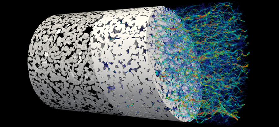
However, many relevant geological structures exist at sub-centimetre scales. For example, fine-scale cross and planar bedding in sedimentary strata (layers) provide important routes for fluid flow and storage. Current models are unable to deal with such levels of complexity and often make assumptions and simplifications. For example, relative permeability and capillary pressure are critical parameters in gas reservoir simulations; accurately predicting these variables is key for managing existing reservoirs and for assessing the suitability of sites for CO2 geo-sequestration (ie, carbon capture and storage).

However, the models used for these predictions have traditionally assumed homogeneous rock types within the reservoir, when in reality, reservoirs often exhibit high heterogeneity at a variety of scales. As such, improving geological models for more effective geoengineering projects requires new workflows and high-resolution geological data to capture millimetre-scale variations of the subsurface.
New workflow for geological modelling
At GeoCquest, an international research consortium between the University of Cambridge, UK, the University of Melbourne, Australia, and Stanford University, USA, researchers Dr Achyut Mishra and Professor Ralf Haese have taken up this challenge.
Through collaborations with numerous other scientists, Mishra and Haese have spent six years developing a new workflow for high-resolution models. The geological models built using their approach have improved predictions of fluid flow and fluid–rock reactions compared with traditionally built geological models.
Harnessing subterranean resources requires detailed subsurface surveys and models.Under the GeoCquest banner, Mishra and Haese have applied the fundamental principles of sedimentary geology to conventional geophysical data. Their new workflow has four main steps:
1. Coarse-resolution data are used to deduce major sedimentary depositional environments in the area of interest.
2. Once possible sedimentary structures have been identified, they are characterised in terms of their mineral composition, the pore volume, and the capacity to allow fluids to flow through them.
3. These sedimentary structures are directly compared to wireline log data (eg, apparent matrix density, neutron porosity, and gamma-ray) sampled at resolutions of ~15cm.
4. Finally, sedimentary structures below the resolution of the wireline logs are determined based on parameters such as grain size and sorting, the degree of cementation, and bed thickness.
Addressing uncertainty with machine learning
As with any geo-survey method, Mishra and Haese’s approach has inherent limitations; however, a critical innovation has been the use of machine learning to mitigate these limitations. For example, steps three and four, where sedimentary structures below the resolution of the wireline logs are inferred based on other known parameters, can introduce errors and uncertainty to the model (eg, uncertainties in rock types). To address this issue, Mishra and Haese developed a machine learning code called Irida to automate this process. Irida learns millimetre-scale variability in rock types from high-resolution QEMSCAN data and uses it to improve the resolution of wireline logs. These enhanced logs can then serve as inputs for building improved geological models.

Another major limitation of high-resolution models is that the number of grid cells in the model can become too large to be efficiently handled in computations. Mishra and Haese have applied machine learning algorithms to identify regions within reservoir models where high-resolution data are actually useful, and regions where such data do not add significant value. Based on this, the number of grid cells in regions where high-resolution data are not required can be reduced via reservoir upscaling or averaging methods, significantly reducing the computational burden.
Applications and outlook
Geological models built using this approach have confirmed that greater resolution can capture improved predictions of fluid flow and fluid–rock reactions compared with traditionally built geological models. For example, mineral trapping is an important mechanism for storing CO2 in the subsurface; however, as these fluid–rock reactions are very slow, simulations are vital for estimating CO2 storage capacities.

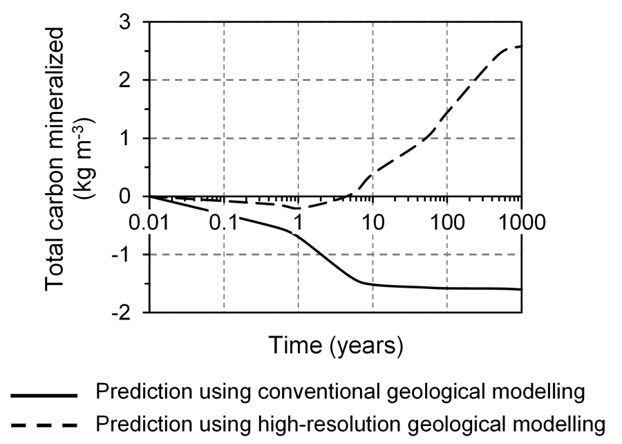
The research team ran both metre- and centimetre-scale fluid–rock reaction simulations of a 630m long geological transect through the Paaratte Formation in the Otway Basin of Australia, 300km southwest of Melbourne. This sedimentary basin, which covers an area of 150,000km2 and has a maximum thickness of 8km, first formed during rifting between Australia and Antarctica. This site was chosen, in part, because it offers a rare natural analogue (in this case, well-characterised natural CO2 mineralisation) for which high-resolution data are available and can be used to validate simulation outcomes. The simulation results were compared with data from the Pretty Hill Formation, a natural CO2 storage area in the same basin that shares a similar mineralogical composition and sedimentary structures. The Pretty Hill Formation is a sandstone reservoir containing 0.5–1cm thin lenses of low-porosity, low-permeability siltstones, which are similar to laminations observed in cores from the Paaratte Formation. The Pretty Hill Formation underwent extensive Pleistocene carbon mineralisation owing to CO2 transported from the mantle.
Greater resolution can capture improved predictions of fluid flow and fluid–rock reactions compared with traditionally built geological models.The results showed that the metre-scale modelling significantly underestimated carbonate mineral formation. In comparison, the centimetre-scale modelling showed carbon mineralisation predictions that were six orders of magnitude higher, and that had excellent agreement with field measurements. In particular, it was the inclusion of detailed lithological heterogeneity – the 0.5–1cm thin siltstone and mudstone layers known as ‘intraformational baffles’ – owing to the fine-scale resolution that allowed the more accurate and significantly higher estimates of carbon storage to be assessed.

The team also applied their approach to modelling the flow of CO2 through the subsurface, which is critical for carbon sequestration applications. They found that small-scale heterogeneities of the site were a major controlling factor in the behaviour of a CO2 plume during the injection stage. In particular, fine-scale changes in the orientation of the reservoir strata had significant impacts on the shape and buoyancy-driven migration of the CO2 plume. Further studies are planned to better understand the plume behaviour in the post-injection stages, although this will require even more computational complexity.
The innovative work of Mishra, Haese, and their research team offers the opportunity to revolutionise geological modelling, particularly in sedimentary environments. In turn, this will facilitate the more effective and efficient use of Earth’s natural resources, and allow us to better harness new and exciting technologies with the potential to address major climate-related challenges facing humanity.
Personal Response
What inspired you to conduct this research?The major inspiration for this work comes from the past two decades of research on this topic where scientists identified and established the importance of centimetre-scale variations in rock properties on fluid flow and fluid–rock reactions in the subsurface. We were motivated to convert the learnings from these findings into a workflow which can then be practically used for building improved geological models.
Has this approach been applied in any operation settings?
The approach has not been applied in an operational setting to-date. However, we are in the process of transitioning our workflow to a user-friendly software tool which can then be made available to researchers in the industry and in academia. This would enhance the application of the workflow to geological modelling projects. The tool should be ready in a year’s time.