The TO-10 site in NW Italy is unsuitable for hosting the national nuclear waste repository
Radioactive materials are used in a variety of sectors, including energy production, medicine, industry, and agriculture. Given the risks to human health and the environment, radioactive materials are strictly controlled, with regulatory guidelines for their production, use, transport, and disposal. The issues of storage and disposal are a global challenge. The International Atomic Energy Agency (IAEA) has established international Radioactive Waste (RW) safety standards for near-surface disposal1, specifically intended for disposal of low-level radioactive materials. Among them, the procedure for selecting waste repositories includes four steps: a) conceptualisation and general site design; b) potential site selection; c) site characterisation based on environmental and socio-political factors (eg, land use, transport infrastructure, demographics, local economic activities, etc); and d) final site selection.
Recently, Italy has started the procedure of identifying suitable sites for hosting its national RW repository. A state-owned company, Sogin SPA (Sogin), has proposed a map (called CNAPI) positioning 67 potentially suitable areas to host the repository. The Sogin selection procedure takes into account the criteria as defined in the Technical Guide no 29 edited by the Italian Institute for Nuclear Safety and Radio Protection (ISIN, 2014). Subsequently, ISPRA introduced several ‘exclusion criteria’ (EC) for rejecting unsuitable sites, and other ‘investigation criteria’ (IC) allowing in-depth investigation to technically characterise potential sites. However, this new procedure ‘distorts’ the original IAEA guidelines since the two groups of criteria may roughly overlap and interfere, putting the reliability of CNAPI into question.

Enrico Borgogno-Mondino and Corrado Cigolini of the University of Torino, and Andrea Borgia at European Development and Research Agency (EDRA), investigated the TO-10 area (Figure 1) for hosting the national deposit for radioactive wastes. The researchers considered the following issues: 1) geological, geomorphological, and hydraulic features of the area; 2) hydrogeological details and characteristics of soils and sediments, which may allow radionuclide transfer into the biosphere; 3) protection and preservation of the area and its cultural heritage; 4) distance of the repository from man-made infrastructures and human activities; 5) distance from underground natural resources; and 6) protection from extreme environmental and weather conditions.
The Italian national repository plan put forward by Sogin will host low- to medium-level radioactive waste. However, Sogin states that the repository will also host high-activity waste for an undefined ‘long-term period’. High-activity waste must strictly satisfy specific IAEA guidelines (‘Geological Disposal Facilities for Radioactive Waste’ 2) that impose the presence of at least an effective geological barrier. In their work, the University of Torino and EDRA researchers demonstrate that, in the case of the TO-10 site, this barrier is totally absent, making storage of even low-level waste a significant risk.
The TO-10 area fully meets the exclusion criterion CE2: ‘an area characterised by a high potential seismicity’.
Geology and tectonics
East of the city of Torino, the Po plain sits between the Alpine chain and the Torino and Monferrato hills, and represents the northern front of the Apennines in Northwest Italy. The main tectonic units in this sector of Piedmont are the Apennine front, juxtaposed to the Alpine retrovergent units that converge below the so-called Po Plain Foredeep. Here, plio-quaternary marine, glacial, and fluvio-glacial massive sediments are covered by late pleistocene-holocene alluvial sediments. This sector of the plain is crosscut by subsidiary rivers and springs, which converge into the Po river and reveal a unique geomorphological and hydrogeological scenario. Extended recharge zones, located at the foothills of the Alps and related moraines, feed the deep aquifers that represent fundamental water resources for human consumption and agricultural uses.
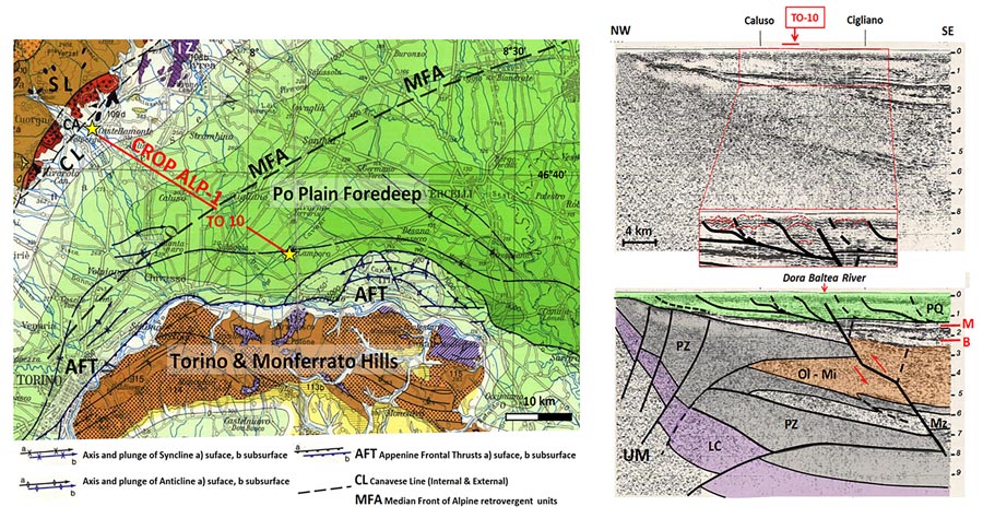
Right: CROP ALP-1 seismic profile along the alignment Castellamonte-Caluso-Lamporo. The TO-10 site location is shown in red. Inset: the role of active tectonics is demonstrated by the existence of a series of folds. PQ: plio-quaternary; M: messinian; B: burdigalian; Ol-Mi: oligocene-miocene; PZ: Alpine retrovergent units; LC: lower crust; UM: upper mantle. Major faults: thick black lines, dashed where approximate.
The CROP ALP-1 seismic profile cross-cutting the TO-10 area is shown in Figure 2. Its analysis demonstrates the stratigraphic setting (geological formations) and related faults. Notably, a major Apennine thrust fault (clearly visible below the Dora Baltea River) displaces the southern Alpine basement units (as far as 8km deep) as well as the overlaying tertiary and quaternary sediments. The role of active tectonics is also demonstrated by the existence of a series of folds (such as ‘fault-propagation and fault-bend folds’), as shown in inset, Figure 2. Importantly, this configuration satisfies the EC3 exclusion criterion: ‘area affected by faulting phenomena’.
Potential seismicity of this sector of the Po plain is obtained on the basis of a geophysical model of the La Sapienza University of Rome (Sogin report DN-GS-00095) with the maximum expected magnitude potentially occurring within the single quadrants (25 x 25km, Figure 3). The maximum magnitude expected for the TO-10 sector can theoretically reach a magnitude of 6.5–6.7, which is typical of some historical earthquakes in this region (eg, the 1117 Verona, 1222 Brescia, and 2012 Emilia earthquakes). Thus, estimated ground peak accelerations occurring within a radius of 5km are well above 0.25g.
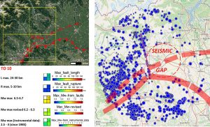
Furthermore, the presence of a ’seismic gap, (obtained from the ISIDE-INGV public catalogue: iside.rm.ingv.it ) indicates that this sector is considered to be at ‘high-seismic risk’ since the seismic energy is not regularly dissipated (as it is in neighbouring areas characterised by greater seismicity, Figure 3). Therefore, the accumulation of elastic deformation can favour the breaking of significant portions of the crust and trigger earthquakes of considerable magnitude. On this basis, the TO-10 area fully meets exclusion criterion CE2: ‘an area characterised by a high potential seismicity’.
In addition to the biogas plant, three high-voltage power lines and a gas pipeline run across the area, presenting significant potential for a major incident.
Geomorphology and hydraulic hazards
Along the Dora Baltea River, the relief of the geological landforms (relict fluvial forms) shows a series of terraces characterised by paleo meanders, riverbeds, and river drainages (Figure 4). These terraces describe successive orders of permanence of the river at higher altitudes compared to current ones. The sector at the southwestern exit from the Mazzè moraine is characterised by four ‘entrenched meanders’ that testify the ongoing tectonic uplift of the area (almost 1.5mm/year). The presence of the ‘Valle della Motta’ active drainage since the pleistocene-holocene period, shows that the TO-10 area is highly vulnerable from a hydrogeological point of view. In fact, the Piemonte region classified the southern sector of this drainage at high-risk of periodic flooding with return times varying between 25 and 50 years. Moreover, the nature and the geometry of the sedimentary cover, as well as the high hydraulic conductivity (10-3–10-5m/s) exclude the presence of a ‘geological barrier’ to the escape of radionuclides, a barrier that IAEA standards require. Consequently, the high and/or extreme hydrogeological vulnerability of this area of the Po plain was demonstrated in 2005, through a cooperative research study by the Torino Polytechnical Institute in collaboration with Sogin. In conclusion, the TO-10 area is remarkably vulnerable from a hydrogeological and alluvial point of view, falling under the EC4 and EC5 exclusion criteria.

Hydrogeology as detectable by open public data
The ISPRA exclusion criterion EC10 relates to the piezometric levels of superficial groundwater. This criterion is applicable when a superficial water table may compromise the degree of isolation of the repository by interfering with its basement and foundations, enhancing the transfer of radionuclides towards the biosphere. The approach taken by the researchers took into account both the aquifer floor and the piezometric head of the water table, as well as the presence of recharge zones feeding the deep aquifer, normally used to supply drinking water (open data source: Regione Piemonte geoportal).
A detailed analysis of these data (Figure 5) shows that: a) the site partially lays in the recharging area of the deep aquifer (NE part of the site); b) a system of wells is present in the area. In particular, eight deeper-aquifer wells (some of them supplying drinking water) within or close to TO-10, making local populations and agricultural activities highly exposed to environmental risk associated with the repository. The whole scenario becomes critical if leakage from the repository were to contaminate the ‘downstream’ wells and the nearby Dora Baltea water table and river. A possible contamination front of radioactive nuclides may also easily reach the Po River, exponentially increasing the nuclear hazard within the whole basin.
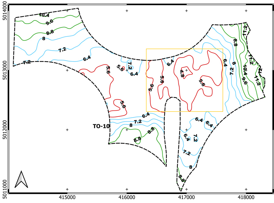
By cross-checking the available ‘piezometric head’ models with digital terrain model data, the depth of the superficial water table was obtained for the TO-10 site. Its depth ranges between 11m (NW sector), down to 4.8m (central/eastern sector). Taking into account the measured seasonal changes within the Vercelli Plain (just 1km east of TO-10), which fluctuate by ±4m, the water table can easily reach the surface (as reported by several local farmers) or interact with the basement of the repository. This fact is particularly critical for the safety of the local and surrounding environment and communities. Thus, according to EC10 the TO-10 area should definitely have been excluded as a potential site. In addition, EC14 criteria are also satisfied due to the presence of relevant hydric resources.
The researchers demonstrate
that the TO-10 site is unfit to host the Italian national nuclear waste repository.
The procedure implemented by Sogin to evaluate the exclusion criterion EC12: ‘distance from inhabited centres’ is organised into three levels: 1) inhabited centres and nuclei; 2) local urban areas; 3) metropolitan areas. Site mapping is based on ordinary geographical information system techniques applied to national ISTAT maps which are out of date (last updated in 2011). During the selection of the 67 sites included in the CNAPI, Sogin applied only the first level of analysis (distance from inhabited centres) by considering a ‘buffer safety zone’ of 1km radius. Despite this minimal approach, Sogin found that the TO-10 site includes two ‘inhabited nuclei’ and one biogas production plant (NW side) whose buffers exclude about 80% of the total surface of the TO-10 area. In addition to the biogas plant, three high-voltage power lines and a gas pipeline run across the area, presenting significant potential for a major incident (EC15), Figure 7.
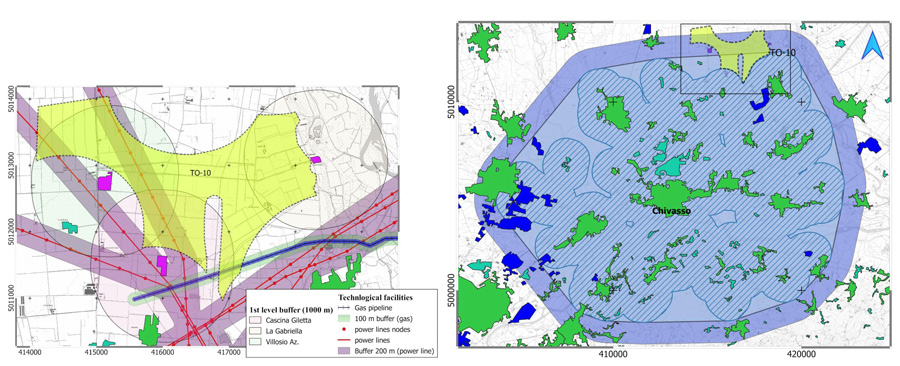
Right: second-level buffer (‘local urbanism’) of the Chivasso municipality.
To test the effects of a higher-level analyses, the researchers applied the second-level (namely,’local urbanism’) to the nearby municipality of Chivasso (over 20,000 inhabitants). Data were processed according to Sogin guidelines (DNGS00198 and DNGS00227), Figure 8.
The applied procedure took into consideration all those settlements (and their first-level buffers) falling within a distance of 5km from the borders of Chivasso. It was found that the resulting potential buffer highly impacts on the TO-10 area and excludes more than 90% of its surface.
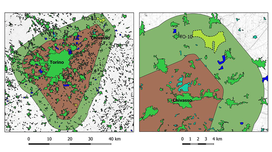
The researchers also performed a third-level analysis, involving the metropolitan area of Torino. They applied the buffers mapped by Sogin, providing them with the appropriate vector maps (shapefile). Here, the TO-10 site is totally included within the ‘buffer zone’ of the Torino metropolitan area, therefore should undoubtedly be excluded as a potential site for hosting the repository.
In conclusion, the researchers demonstrate that the TO-10 site is unfit to host the Italian national nuclear waste repository. These findings were not unexpected: earlier investigations by ENEA (2003) and the Polytechnic of Torino, in cooperation with Sogin (2005), excluded TO-10 as a possible target site. It is therefore unclear on what basis this area was recently included within the CNAPI procedure.
1 IAEA specific safety guide no SSG-29, 2014.
2 IAEA safety standards, series no SSG-14, IAEA, Vienna, 2011.
Personal Response
Where is radioactive waste currently processed in Italy?
At this time radioactive wastes in Italy are stored in several deposits within and/or nearby dismissed nuclear power plants and research laboratories. Some high-activity wastes have been processed abroad, where they are currently stored.
Do you think a suitable area can be identified to create a single national radioactive waste repository?
Nowadays this procedure is ongoing: we simply challenge the lack of adequate preliminary investigation by Sogin that led them to consider the TO-10 area as a potential site for hosting the national radioactive waste deposit. A feasible site should be explored in areas where the substratum is characterised by impermeable rocks (that warrant the presence of a reliable geological barrier and the absence of hydrogeological vulnerability), and can be found within less populated regions subject to lower environmental pressure.