Triharmony/Trilemma of Carbon Assets in tropical peatland
Tropical peatlands provide globally important reservoirs of water and carbon, and the cycles of these two elements are intricately connected. At Hokkaido University, Sumitomo Forestry Co, Ltd, Japan, and BRIN, Indonesia, scientists have developed a model for mapping carbon emissions from tropical peatlands. Their integrated monitoring, reporting, and verifying (iMRV) system measures dynamic changes in water and carbon cycles, biomass and biodiversity, forest degradation, and the impacts of climate change and human interference. A better understanding of these systems in tropical peatlands will help foster long-term sustainability practices, reduce carbon emissions, and increase carbon sequestration.
Peatlands are defined by the presence of peat materials, which are rich in carbon materials (particularly lignin). They have a high water content which results in low-nutrient and low-oxygen conditions, but abundant humic acid. The oxygen is limited because it cannot be dissolved into water in any great quantity. The resulting low (but not absolutely low) soil redox potential (Eh, the ability to lose electrons) regulates the emission of greenhouse gases from tropical peatlands. For example, CO2 emissions are minimised because the low Eh, along with limited nutrients, restricts microbial activity; methane (CH4) emissions are minimised because the Eh is relatively high (not absolutely low) for methanogenesis (anaerobic organic degradation). Consequently, tropical peatlands provide globally important reservoirs of water and carbon, and the cycles of these two elements are intricately connected (1).
Water is found within two main ecosystem reservoirs: groundwater and soil water. Levels of water storage are controlled by the balance between evapotranspiration (evaporation and transpiration of water from the land and leaves, respectively) and precipitation (the transfer of water from the atmosphere to the ground). These processes are not static, and are increasingly variable owing to climate change. For example, in the tropical peatlands of Southeast Asia, phenomena such as Indian Ocean Dipole (or IOD, the irregular changes in sea-surface temperatures in Indian Ocean area) causes prolonged drought at Maritime Continents (MC) in Southeast Asia, especially in Indonesia’s tropical peatlands. Importantly, a recently published study shows that positive IOD events – not El Niño – act as an alert for lowering the groundwater level, and causing peat fire in the Indonesian MC (IMC) (2). In addition, the land use, land-use change, and forestry (LULUCF) all have profound impacts on water cycling. Deforestation for the development of agriculture and/or plantations not only results in biodiversity losses, but also changes the balance between evapotranspiration and precipitation, usually resulting in the drying of peatlands, which are naturally high-moisture environments.
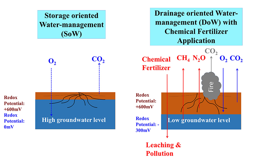
These changes in the water cycle lead to increased carbon emissions, which are stimulated by oxidation via either fires or microbial activity (known as ‘hot fire’ and ‘cold fire’ oxidation, respectively). However, appropriate water management strategies in agricultural/silvicultural areas can be used to mitigate these changes, and even result in a carbon-negative system. As many commercial plants are sensitive to high groundwater level, conventional water management in tropical peatland areas has focused on drainage, known as ‘Drainage orientated Water-management’ (DoW) (3). The long-term consequences are that the peat soil dries out (causing increased fire risk), biomass is reduced (including reduced agricultural productivity), and carbon is released into the atmosphere, which induce a devastating Trilemma state (4).
Global efforts to combat climate change are widely perceived to focus on reducing emissions of greenhouse gases; however, a lesser-known part of the strategy is to increase peat soil carbon stocks via peat soil carbon sequestration. At Hokkaido University, Japan, Professor Osaki and colleagues have found that a ‘Storage orientated Water-management’ (SoW) approach in tropical peatlands – known as ‘AeroHydro culture’ – can maintain high groundwater levels and promote biomass production and carbon sequestration (1).
The effective and large-scale application of SoW (an example of eco-management) to arrest rising atmospheric carbon, requires comprehensive understanding of the spatial distribution of peat soil carbon, carbon flux, and methane emissions. To this end, Osaki and his team have developed a new model – the Water-Carbon Interaction Model – to better estimate spatial variations of carbon and their links to human activity and climate change.
Tropical peatlands provide globally important reservoirs of water and carbon.Peat soil carbon mapping
Carbon sequestration and low-carbon technologies are under development around the world. However, if we are to avoid the potential devastating consequences of escalating climate change in coming decades, carbon sequestration must begin in earnest now. Among Earth’s main carbon reservoirs, increases in atmospheric and oceanic carbon are problematic and are already causing significant climatic and environmental issues; storing carbon as fossil fuels takes millions of years; and carbon capture and storage remains technologically immature and prohibitively expensive. This leaves a final significant reservoir that can be exploited on a short-to-medium-term timescale: shallow carbon stored in soil and biomass. The goal for global soil carbon storage, as agreed at COP21 (Paris, 2015), is to increase soil organic matter in the top 1m of soil by 0.4% per year; it is estimated that meeting this goal would offset a massive 20–35% of global greenhouse gas emissions.
As a global average, it is estimated that there is 161t of soil organic carbon per hectare; however, the carbon contents of soils vary among the different climate zones. Global maps of soil carbon content clearly show that arid and semi-arid areas support carbon-poor soils (10–30t of carbon per hectare), while the boreal forests of Russia, Scandinavia, and northern North America, which all support rich areas of peatland, are the most carbon-rich areas (120–150t of carbon per hectare). However, peatlands are also found in tropical areas along the Equator, particularly in Southeast Asia, Congo Basin of Africa and South America. After boreal peatlands, these tropical peatland areas are the next rich reservoir of soil-bound carbon (60–150 t of carbon per hectare).
Carbon flux and CH4 emissions mapping
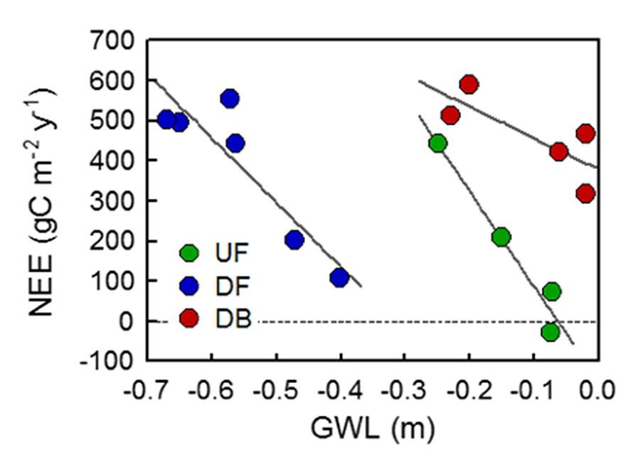
Carbon flux mapping is critical for managing carbon resources. Various methods and models have been developed to estimate the peatland carbon flux. Satellite technology offers the ability to estimate carbon flux at relatively low cost and high spatio-temporal resolution. Osaki and colleagues have harnessed this technology to develop a new estimation model. For example, they used data from a National Aeronautics and Space Administration satellite, the Soil Moisture Active Passive satellite, to observe strong correlations among groundwater level, the subsidence of soil peat, and carbon emissions. For every 0.1 m/year fall in groundwater level, there is an increase in carbon emissions of 89 gC/m2/year. Consequently, emissions are higher during the dry season or during droughts (eg, those caused by IOD) (2).
Methane (CH4) is the second most important greenhouse gas in terms of global climate change. Despite its relatively lower atmospheric concentration compared to CO2, CH4 is a highly potent greenhouse gas, second only to N2O. CH4 maps show that approximately 50% of its annual emissions are anthropogenic. Wetlands are major contributors to natural CH4 emissions, comprising 20% of total global emissions (including natural and anthropogenic), with critical emissions zones concentrated in the tropics and boreal north.
Given these findings, and the links between water level, Eh, oxidation, and carbon emissions, it is clear that a stable, high water environment is conducive to minimising CO2 and CH4 emissions from tropical peatlands. Even in high water level, CH4 emission is not very high because Eh is not absolutely lower (-300 mV) owing to poor nutrients condition, which restricts microorganism activity, allowing O2 to diffuse deep into the peat layer (1). Conversely, in oil palm plantations, when water is drained (DoW) inducing a low groundwater level, and large amount fertilizer (especially nitrogen fertilizer) is applied, 1) CO2 emission increases by oxidation (fire and microorganism degradation), 2) CH4 emission increases by lowest Eh (-300 mV) by microorganism activity, 3) N2O emission increases by oxidation (1) (Figure 1).
Moreover, the work of Osaki and colleagues shows that the SoW, in which a high groundwater level is maintained year-round via AeroHydro culture (1), is also conducive to increased biomass production. This not only reduces losses to biodiversity and biomass yields, but also increases carbon sequestration in peatland.
Changes in the water cycle lead to increased carbon emissions.Integrated Monitoring, Reporting, and Verifying (MRV) system
Until relatively recently, peatlands offered a stable and important reservoir for water and carbon; however, this is under threat from anthropogenic climate change. The Triharmony management of peatlands depends on the continued balance between carbon, water, and nutrients. Sadly, intensive agriculture and poor agricultural practices have destroyed this balance over large areas and long years.
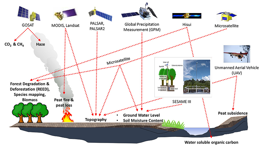
Osaki and his team argue that preserving surviving areas and restoring those already damaged should be a priority in the quest for climate change mitigation strategies. To this end, they propose an integrated Monitoring, Reporting, and Verifying (iMRV) system to report on dynamic changes in water and carbon cycles, biomass and biodiversity, forest degradation (including deforestation), and the impacts of climate change and human interference. The iMRV system can operate at high resolution (<100 m2) and in real-time, using a range of satellite sensors operating in different sections of the electromagnetic spectrum. The outputs offer the ability for three-dimensional (3D) analysis and are ground-truthed using drone technology and other satellite products.
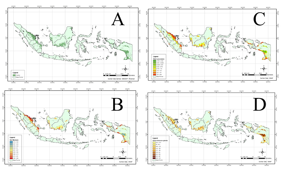
C. Groundwater level measured on February, 2018, and D NEE (CO2 emission), February, 2018.
While this approach can be applied globally, the team has focused much of its attention on tropical peatland areas for a number of reasons. Chief among them, tropical peatlands have been degraded at an alarming rate owing to commercial agriculture (primarily oil palm), slash-and-burn practices, and illegal logging. However, the warm and humid climate conditions offer the potential for relatively rapid regeneration, assuming that appropriate remediation approaches are taken (eg, the implementation of the SoW system). As such, a major new initiative to complement iMRV is the informatics-based Equator/Earth Observation System (iEOS), which uses several different spectral products, 3D photogrammetry, and a greenhouse gas sensor aboard Equator orbiter. The satellite collects data from areas along the Equator several times a day allowing for the creation of mosaic images, avoiding clouds. This mitigates one of the main challenges of equatorial remote sensing: high levels of cloud cover. The iEOS offers significantly improved abilities to measure variables such as groundwater level, soil moisture, SOC, carbon flux, CH4 emissions, plant nutrients phenology, and plant diversity (1).
Personal Response
When will the iEOS be operational and will its outputs be available to the general public? Do you anticipate that large-scale agricultural businesses will have the expertise and inclination to use such a resource to combat their carbon emissions?As the iEOS targets the Tropical Zone, it greatly contributes to the NbS (Nature-based Solution) of tropical countries. We are equipping the iEOS with hyper-sensor spectrum analysis, high resolution measurement of infrared spectrum thermal radiation (to monitor temperature and greenhouse gases), and detection of gravitational anomalies (mainly to monitor water movement on land and sea); all of which will contribute to a better understanding of the global ecosystem. We believe that the iEOS will be the most reliable and low-cost tool for contributing to Earth regeneration.