Dousing the flames: A model approach to fire management
Fire management is complex, and strategies that work in one geographic area are unlikely to work in another owing to the unique geographical, ecological, and socioeconomic conditions. Professor Trent Penman at the University of Melbourne, Australia, is using Bayesian decision networks to model cost-effective wildfire management options (ie, types of prescribed burning). The model shows that no single cost-effective solution is common to all areas, although controlled burns on urban margins are more effective than those in the landscape. However, the use of prescribed fires remains socially unacceptable to some stakeholders.
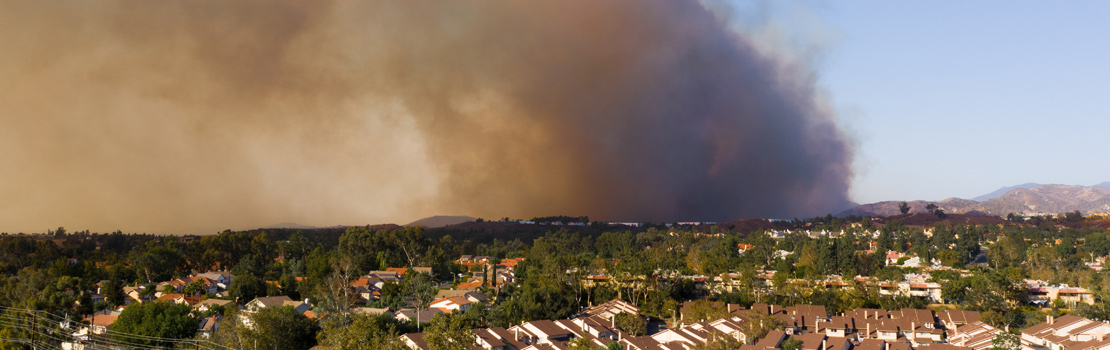
Wildfires are important natural phenomena that are critical for ecosystem renewal and health; however, when these intersect with humans, the results can be catastrophic. Each year, wildfires are responsible for losses of life and infrastructure around the world, causing damage to communities and livelihoods. Moreover, wildfires alter landscapes and ecosystems. The year 2020 saw spectacular and devastating wildfires burning across vast areas of Europe, the United States, South America, and Australia—those in California and Australia gained particular notoriety for setting new and sobering records. In California, the summer fires of 2020 were the first in modern history to burn across a million acres, earning a grim ‘gigafire’ label. In Australia, the ‘black summer’ of 2019–2020 saw 21% of the nation’s temperate broadleaf forest alight; previous bushfire seasons have seen no more than 2%.
Wildfire behaviours are intensified by drought conditions and high temperatures; both of which are increasingly common and increasingly severe impacts of global climate change. Moreover, with population pressures and urban sprawl, more and more humans are living and working in areas of high fire risk, increasing both the chance of fires occurring (while some fires start naturally, others have a human origin), and the consequences when they do. As with all natural disasters, when the smoke clears, questions are raised; in particular, what could have been done to minimise the losses to life, infrastructure, economies, and ecosystems?

In reality, there is currently only a limited range of actions that fire agencies can take, and worse, few data that tell us what the return for investment on these actions are. Critically, strategies that work in one geographic area are unlikely to work in another owing to unique geographical, ecological, and socio-economic conditions. More often than not, the impacts of disasters are measured in terms of money; however, at the University of Melbourne, Australia, bushfire risk modeller Professor Trent Penman is questioning whether dollar values are the appropriate metric when managing wildfires to protect human life. In particular, environmental, social, and cultural costs are poorly represented in current models. With support from the Bushfire and Natural Hazards Cooperative Research Centre, Victorian Department of Environment Land Water and Planning, New South Wales (NSW) Rural Fire Service, NSW Department of Planning, Industry and Environment, Professor Penman and his colleagues (Brett Cirulis, Hamish Clarke, Matthias Boer, Owen Price, Ross Bradstock, and Bruce Marcot) are attempting to address this issue within a framework of wildfires and fire management.
The impacts of disasters are measured in terms of money… environmental, social, and cultural costs are poorly represented in current models.
Predictive modelling for wildfire management
Wildfires and their impacts present complex, interacting systems that vary across space and time. Managing such hazards is challenging; decisions must be made and resources expended in the face of huge uncertainties – social, economic, ecological, not to mention the uncertainty inherent in the process and progress of the fire itself – and many competing (and often conflicting) interests. To address these issues, Penman and his colleagues developed a Bayesian decision network (BDN), a form of predictive modelling for risk analysis that is at once simple and also able to account for uncertainty in complex systems. In BDNs, decisions and their cost (or benefit) are based on probabilities of given outcomes. BDNs have been widely used for environmental risk analysis and decision making. However, Penman and his colleagues are the first to use this approach to explicitly consider the relative benefits of various wildfire management approaches as a function of their natural and human asset costs.
For development purposes, the team focused on Victoria, Australia, considering wildfire management in an area north-east of Melbourne and characterised by urban, agricultural, and woodland (both natural and plantation) areas. The area is prone to wildfires with distinct seasonal patterns (low intensity activity in spring, increasing in summer); since 1927, there have been 15–40 recorded wildfires per decade. The BDN took into account the fire danger index (calculated from temperature, relative humidity, wind speed, and a long-term drought factor); assets in the natural environment (amount of carbon released per fire, and area burnt that is expected to reduce biodiversity); assets in the build environment (number of houses lost, and length of powerlines lost); and two management approaches – prescribed burning (ie, controlled fires) within 500m of the edge of an urban area (edge treatment), or prescribed burning in the landscape (landscape treatments).
The strength of the BDN lies in its flexibility and ability to accept data of many types and on different scales, from meteorological data, to financial estimates, to geographical areas, to numbers of structures, etc. Compared with more traditional simulation models, the simplicity of the BDN model structure allows for a relatively low computational load and the ability to update or change the input data with ease. Moreover, while Penman and his colleagues considered four asset nodes and two management decision nodes, the same model structure could be used with additional nodes to meet the needs of specific situations.
The model was found to be particularly good at predicting fire area and housing losses; moreover, the most cost-effective fire management approach (ie, that which best balanced the cost of management activity vs. the cost of doing nothing) was prescribed burning along 15% of the urban edge area. The least cost-effective approach was found to be annual prescribed burns of 10%–15% of the landscape area. However, while these outcomes were robust to changing model parameters, decision-making remains a challenge. For example, burning such large areas close to urban centres is often not acceptable to local populations, many of whom chose to live in edge areas owing to the environmental benefits, and are willing to accept a certain level of wildfire risk to maintain that privilege; moreover, such edge treatments do little to protect dispersed assets such as powerlines. Edge treatments also come with higher costs of implementation compared with landscape treatments, and some stakeholders may feel that these resources are better spent on other essential services in the community.
Prescribed burning in different landscapes
To further validate the BDN approach, and to investigate landscape-level variation in the optimal management approach, Professor Penman and his colleagues next applied their method to 13 diverse landscapes of south-eastern Australia; in contrast, the vast majority of previous wildfire management studies have focused on just one or two case study locations. The 13 sites, each between approximately 45 and 60km2, covered a range of ecosystems, climates (arid, temperate, sub-tropical), altitudes (sea level to 2,000m above sea level), and levels of urban development.
Wildfires and their impacts present complex, interacting systems that vary across space and time.
After collecting data on fire history for each of the 13 regions (including weather and ignition locations), the team ran simulation models assuming different historical weather conditions and management approaches (ie, prescribed fire scenarios). From these simulations, the impacts on five assets were estimated (in addition to the four assets previously included, loss of human life was also considered). Finally, data from the first three steps were applied to the BDN to examine the most cost-effective approaches in the different regions.
Critically, the results showed no single cost-effective solution that was common to each of the 13 areas. In fact, cost-effective solutions were found for just 25% of areas, and the cost effectiveness of various approaches varied widely, mainly reflecting spatial variations in assets and vegetation. In general, edge treatments were preferable to landscape treatments in reducing impact; however, the cost of treatment often exceeded the cost saved. Continuous vegetation along urban edges was correlated with more cost-effective strategies compared with fragmented vegetation. However, the most critical finding was that cost effectiveness is closely related to the spatial distributions of houses and people relative to the location of the prescribed burn.

Looking beyond the financial cost
The goal of Penman and his colleagues is to optimise investment in fire management across different environments. By exploiting the simple structure and strong predictive ability of BDNs, they have been able to identify the main drivers behind the cost effectiveness of prescribed burning approaches (ie, the layout of the built and natural environments, closely followed by expected fire weather). However, the specific social, cultural, and ecological characteristics of a given area determine the best course of action. Moreover, management choices are further complicated by the fact that ‘cost’ is not the only consideration. Prescribed burning as a management strategy is unpalatable to some; finding effective approaches that are socially acceptable to all stakeholders remains perhaps the most significant challenge of all.
Personal Response
Aside from prescribed burning, what other management options are there?
There are a range of other management options that agencies consider. Fuel management covers treatments such as prescribed burning, mulching, slashing, and clearing. All of these focus on changing the fuel structure and load. We have significant investment in the complex area of fire suppression, ie, fire trucks, helicopters, aeroplanes, etc. These all work together or independently to put out or slow the spread of a fire, as well as protect key assets in the landscape. Agencies also engage with communities and individuals to ensure they have prepared themselves and their property for fire.
Where do you see your model development going in the future?
In the future, we hope to be modelling fire regimes not just fires. Fire regimes are important as they consider the sequence of fires and the impact of multiple treatments on areas over time. These regimes are important for better understanding the impact of fire and fire management on environmental and human assets. The model also does not consider the impacts of cultural fire and contemporary fires on indigenous values. This is a major limitation of the approach and we are working with indigenous researchers to cover this gap.